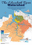
Watershed Action Plan Map showing the main branch of the Elizabeth and its eastern, western and southern branches including the Lafayette River and Indian Rivers, Scotts Creek, Broad Creek, Paradise Creek, St. Julian’s Creek and Money Point.
Highlighting the health of the river by Good, Marginal, Degraded and Severely Degraded areas and featuring the locations of Model Level River Stars, oyster restorations, wetland restorations and sediment clean up sites.
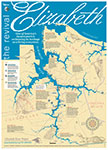
Graphically underscoring the importance of the Elizabeth’s revival, this map proudly announces “One of America’s busiest ports is reclaiming its heritage as a living ecosystem.” The map does double duty in that it highlights the sites of historical significance and sites of restoration, although more have been begun since this map was created by John Earle, graphic illustrator for The Virginian-Pilot.
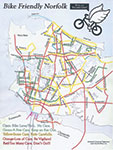
Routes and traffic tips, provided by Norfolk resident Wes Cheney, member of Norfolk Critical Mass, part of an effort to encourage safe biking in Norfolk.